Houston’s sunny, hot weather continues with only a single mystery: What happens with a weak front this weekend?

In brief: Houston’s sunny and hot weather continues, but we’re watching for modest impacts from a dying front on Saturday or Saturday night. Rain chances from this front are not great, but they’re the best we’ve seen in awhile around here.

Overview

High pressure will dominate for a few more days before a weak front squeezes into Texas on Saturday or Saturday night. This will bring us a brief shot at some showers (and possibly a thunderstorm or two, but probably not), and possibly a few hours of slightly lower humidity. The timing of the front is important here. Following this we’ll be back to hot and sunny weather for the majority of next week, although temperatures might be 1 or 2 degrees cooler than this week. Maybe. It’s gonna be August so you know it will be miserable.
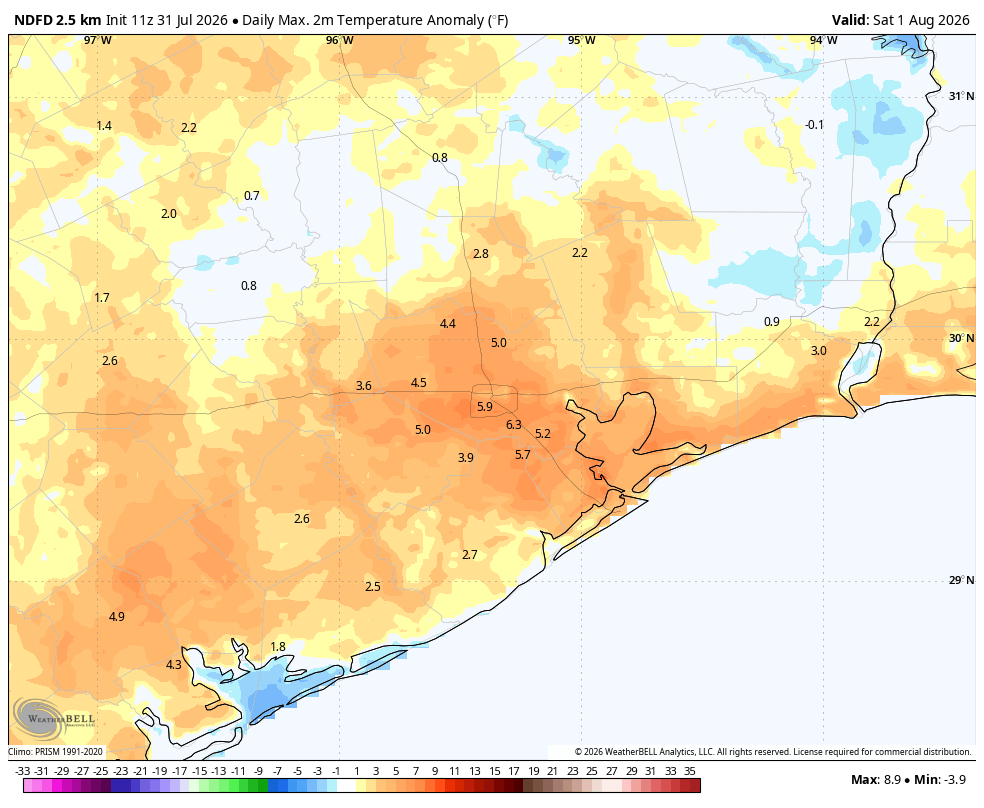
High temperatures today will be 4 to 6 degrees above normal for most of the region. (Weather Bell)

Friday

Today will be like the rest of this week so far: highs in the upper 90s to 100 degrees, sunny, humid, and hot. Light winds this morning will turn gusty later this afternoon and into the evening hours. Lows remain sultry, only dropping to around 80 degrees or slightly below.

Saturday

Weakening high pressure will allow a front to slip into Texas on Friday and Saturday, and by Saturday afternoon or evening it should approach the greater Houston area. The timing is important, because if the front reaches the metro area during the afternoon or early evening there will be plenty of heat for it to help generate some showers and thunderstorms. If not, then there will be less coverage. For now let’s go with rain chances in the vicinity of 30 percent during the period of Saturday afternoon through the overnight hours. Aside from this, Saturday is still going to be hot, sunny, and humid.

Sunday and Monday

These will be hot days with highs in the vicinity of 100 degrees. The wrinkle is that our air mass might be slightly less humid due to the front’s arrival. Not knock-your-socks-off lower humidity, but the kind of thing you may be able to feel on Sunday morning or evening. Or not. Rain chances both days are near zero.
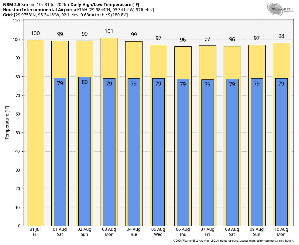
Highs may come down a couple of degrees next week. (Weather Bell)

Next week

Houston’s weather turns slightly more normal-ish for August next week, with highs in the mid-90s to upper-90s most likely, and perhaps a 10 or 20 percent chance of afternoon showers. In general, this is pretty miserable. But because this is August, it’s pretty much the norm around these parts.

Have a wonderful weekend, everyone. We’ll see you on Monday morning.

Heat continues, with a slight chance of rain showers this weekend

In brief: In today’s post we discuss high pressure, and what impacts the region might see from a weak front that will move in from the northeast this weekend. Also, August looms.

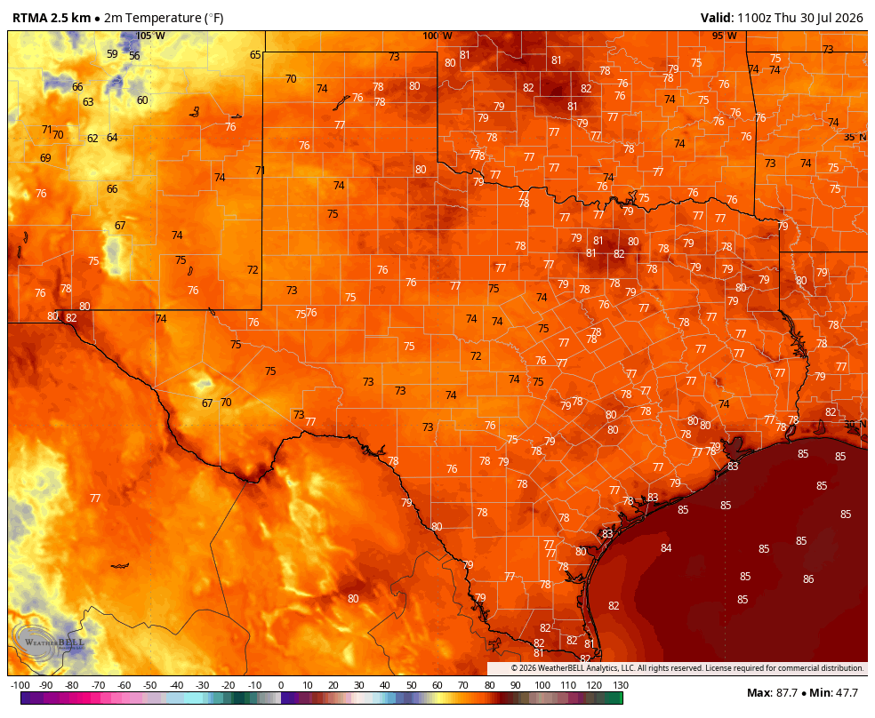
The only cool air in Texas this morning can be found on a few peaks in the Davis Mountains in West Texas. (Weather Bell)

Big picture overview

High pressure continues to dominate our region’s weather, and it will do so for the rest of the work week. By this weekend high pressure will slowly ease westward, allowing a weak front to drop into East Texas. Since we are literally in the dead of summer, this front likely will not bring too much in the way of meaningful relief to our humid air mass. However it could spark a chance of showers later on Saturday, Saturday night, or Sunday. These would be briefly lived. High pressure likely returns next week, bringing more high summer heat along with it.

Thursday, Friday, and Saturday

If you liked the weather the past couple of days you’re in luck, because that’s more or less in store for the next three days. We can expect highs in the upper 90s to the low 100s, with sunshine and ample humidity. Light south winds will become a bit gusty during the afternoon hours. Rain chances? Maybe 10 percent daily, although by Saturday evening or Saturday night they may bump up to around 30 percent given the backdoor front mentioned above.

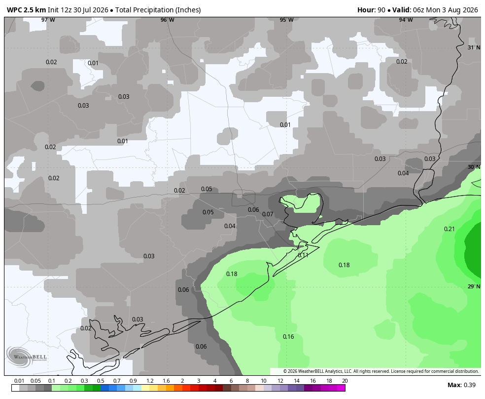
NOAA rain accumulation forecast for now through the weekend. Set your expectations accordingly. (Weather Bell)

Sunday

Skies will again be mostly sunny and hot. However we may well see some scattered showers and a few thunderstorms associated with the backdoor front during the daytime. The other thing I’m watching for is the potential for slightly lower dewpoints, in the 60s. If this were to happen it probably would be in the Sunday morning to Sunday evening time frame, for areas north of Interstate 10. The lower humidity effect would be very modest, but potentially noticeable. No promises.

Next week

Next week’s weather looks a lot like this week’s: Very hot, humid, and sunny. Possibly some increased rain chances toward the end of next week. Possibly.

Houston’s weather is hot, hot, hot. The Atlantic tropics are not, not, not.

In brief: In today’s post we discuss the quietude in the Atlantic tropics, and when that could begin to change. Also, our heat continues for as far as the eye can see, although there are some slight rain chances out there.

A quick look at the Atlantic

Nearly a week after Tropical Storm Bertha moved into Texas the overall picture in the Atlantic tropics remains very quiet. It is possible that a weak system forms off the Eastern Seaboard of the United States next week, but it likely would be moving away from land. The Gulf and Caribbean remain very quiet, and this is due in part to rather high wind shear levels across these basins.

Overall, things look good for the next couple of weeks, which is about how long we can reasonably expect to forecast out. It will be about that time, August 10 or so, that historically the Atlantic tropics start to take off. This is the point in the season when tropical waves start to move off the West African coast into the Atlantic, and strengthen into tropical storms and hurricanes as they propagate westward across the ocean in what is known as the “main development region.”

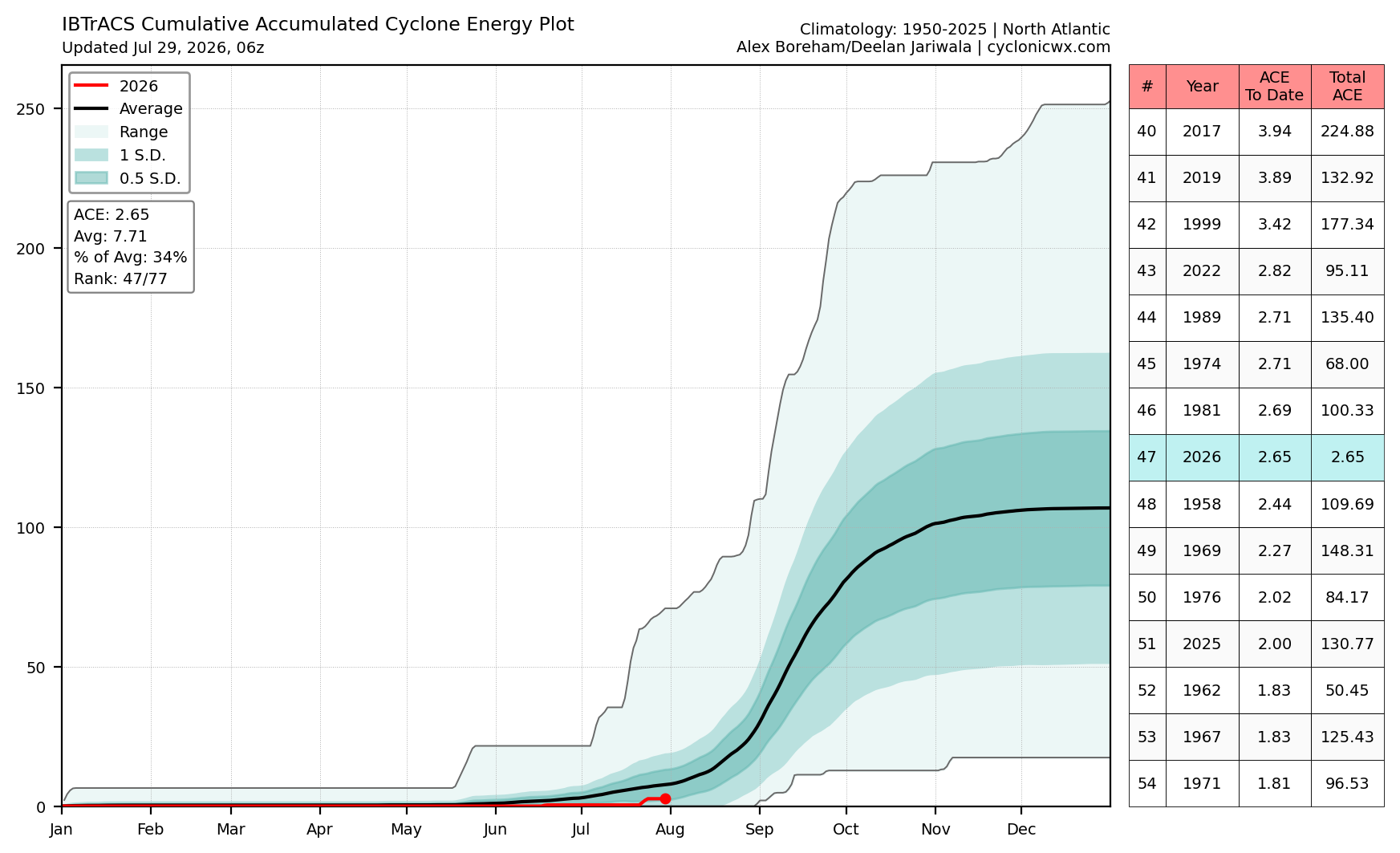
Plot of accumulated cyclone energy in the Atlantic basin for 2026, to date. (cyclonicwx.com)

You can see this burst in activity in the above plot of “accumulated cyclone energy,” which starts to spike later in August and activity remains high into early October. This year (note the red line) activity is significantly below normal, just 34 percent of a typical total. That’s a great start, and to be clear we expect an overall fairly quiet season given a strengthening El Niño, but the bulk of this season lies ahead. We will need to get through August and most of September before giving an all clear for the year in Texas.

Wednesday

The high temperature at Bush Intercontinental Airport reached 97 degrees on Tuesday, and that should be the region’s coolest day for awhile. Highs today will probably reach around 100 degrees, with plenty of humidity and mostly clear skies. Of (slight) note there is about a 10 percent chance of showers or isolated thunderstorms this afternoon due to a potential break in the capping inversion. Winds pick up out of the south later this afternoon. Lows tonight will be around 80, or just below.

Thursday through the weekend

Our hot weather continues. Expect highs in the vicinity of 100 degrees, or the low 100s, for most of the Houston region away from the coast. Near the Gulf waters, highs will be a few degrees cooler. The models continue to indicate a decent chance of rain on Saturday night or Sunday, perhaps 30 percent. Is this a mirage? We’ll see. But mostly we’re going to be sunny and hot.

Next week? Yeah, it’s going to be hot too. (Pivotal Weather)

Next week

For now, I’m leaning toward the “not much changes next week” scenario. Welcome to high summer, y’all.

It’s that time of year again: We need to talk about “Wet Bulb Globe Temperatures”

In brief: In today’s post we talk about Wet Bulb Globe Temperatures, which are useful at this time of year to help differentiate “hot” weather from “extremely hot” weather you need to avoid being outdoors during. We’re going to see some of the latter this week.

WBGT, and what does it mean for me

There are many ways to talk about heat: high temperatures, the heat index, “extreme” heat warnings, and more. But the most practical (which also, I acknowledge, has the most confusing name) is something called Wet Bulb Globe Temperatures. It takes a lot of factors into account, including temperature, humidity, wind speed, Sun angle and cloud cover to determine the amount of heat stress. It is particularly helpful for determining whether outdoor exercise or work is safe. If you have kids in fall sports or marching band, these temperatures are often used to set practice times.

The confusion comes not just from the name (what the heck is a “wet bulb” anyway?) but also because there are other, similar names. For example, a dry-bulb temperature is the name for an air temperature measured by a standard thermometer in the shade. A wet-bulb temperature involves placing a wet cloth around a thermometer bulb, and it measures both temperature and humidity. Globe temperature measures radiant heat (i.e. sunlight and heat radiating from surfaces such as concrete).

All three of these are factored into a “Wet Bulb Globe Temperature.” So yes, it’s a bit complicated, but WBGTs are the very best way of differentiating between “hot” temperatures and really hot, borderline-unsafe temperatures.

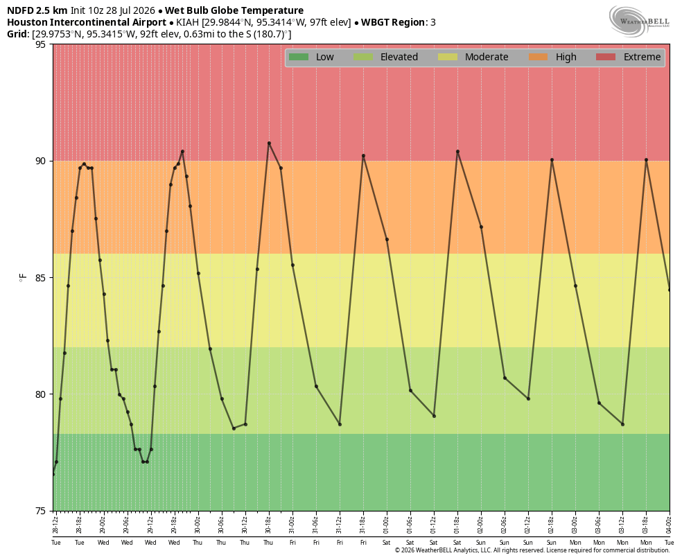
WBGT forecast for Houston’s Bush Intercontinental Airport this week. (Weather Bell)

This week we have a sustained stretch of “extreme” heat in terms of WBGTs. We’ve certainly seen hotter, but each day this week from about 1 to 3 pm CT we will experience extreme or very high WBGT conditions. It’s the time of year to take heat warnings safely. We typically see them in July, August, or early September.

Tuesday through Saturday

There is no mystery with our upcoming weather. High temperatures will be about 100 degrees in Houston for the next couple of days, and then push into the low-100s during the Thursday through Saturday period. It will be our hottest weather of the year. Along with the heat we’ll have plenty of humidity, sunshine, and generally light winds that will gust up to about 15 mph during the afternoon hours. Nights will remain warm and sultry. And that’s pretty much it—for most of us this is pretty brutal weather.

Sunday and beyond

High pressure begins to retreat toward the end of this week, and that will open up the possibility that we see some slightly different weather by the end of this weekend, and during the first half of this week. Best case? Daily high temperatures fall back into the mid-90s, and we see some decent daily rain chances. Worst case? We more or less continue the conditions of this week, and keep on trucking with very hot days and full sunshine. We’ll have to see how things play out.